![](/images/other/stat-length.png)
![Tocht Te voet Mníšek pod Brdy - NS Mníšek pod Brdy - Photo](https://media.geolcdn.com/t/1900/400/2a565180-058b-44a6-b5b6-fdf61dda7657.jpeg&format=pjpeg&maxdim=2)
NS Mníšek pod Brdy
SityTrail - itinéraires balisés pédestres
Tous les sentiers balisés d’Europe GUIDE+
![Lengte](/images/other/stat-length.png)
Lengte
3,6 km
![Max. hoogte](https://static1.geolcdn.com/siteimages/upload/files/1508320355ic_sort_altitude_max_24dp.png)
Max. hoogte
550 m
![Positief hoogteverschil](https://static1.geolcdn.com/siteimages/upload/files/1508320355ic_sort_den_pos_24dp.png)
Positief hoogteverschil
50 m
![Km-Effort](/images/other/stat-length.png)
Km-Effort
4,7 km
![Min. hoogte](https://static1.geolcdn.com/siteimages/upload/files/1508320355ic_sort_altitude_min_24dp.png)
Min. hoogte
382 m
![Negatief hoogteverschil](https://static1.geolcdn.com/siteimages/upload/files/1508320355ic_sort_den_neg_24dp.png)
Negatief hoogteverschil
191 m
![Boucle](https://static1.geolcdn.com/siteimages/upload/files/16400158638029165_repeat_loop_refresh_sync_direction_icon.png)
Boucle
Neen
Markering
Datum van aanmaak :
2025-02-07 20:56:36.141
Laatste wijziging :
2025-02-07 20:56:36.141
![Te voet](https://static1.geolcdn.com/sitytour/trail-icons/100.png)
1h04
Moeilijkheid : Gemakkelijk
![Scan deze QR-code om de tocht te openen in de SityTrail-applicatie](https://capi.geolives.com/qq0zvz2zws4bq2lad0pu/sitytour/trails/4346742/qr.png?size=200)
Gratisgps-wandelapplicatie
Over ons
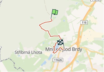
Tocht Te voet van 3,6 km beschikbaar op Centraal-Bohemen, Onbekend, Mníšek pod Brdy. Deze tocht wordt voorgesteld door SityTrail - itinéraires balisés pédestres.
Beschrijving
Tocht aangemaakt door cz:KČT.
Plaatsbepaling
Land:
Czech Republic
Regio :
Centraal-Bohemen
Departement/Provincie :
Onbekend
Gemeente :
Mníšek pod Brdy
Locatie:
Unknown
Vertrek:(Dec)
Vertrek:(UTM)
446361 ; 5525343 (33U) N.
Opmerkingen
Wandeltochten in de omgeving
![Tocht Te voet Černolice - NS Putování Černolickem - Photo](https://media.geolcdn.com/t/375/260/3d6ca1f7-5098-486f-a0ff-96334a205635.jpeg&format=jpg&maxdim=2)
![Te voet Te voet](https://static1.geolcdn.com/sitytour/trail-icons/100.png)
NS Putování Černolickem
Te voet
Gemakkelijk
Černolice,
Centraal-Bohemen,
Onbekend,
Czech Republic
![](/images/other/stat-length.png)
4,2 km | 6 km-effort
1h 21min
![](https://static1.geolcdn.com/siteimages/upload/files/16400158638029165_repeat_loop_refresh_sync_direction_icon.png)
Ja
![Tocht Te voet Mníšek pod Brdy - [M] Mníšek pod Brdy (žst) - Bratřínov - Photo](https://media.geolcdn.com/t/375/260/75654143-a563-4dd5-938a-a7f76f5b1c9f.jpeg&format=jpg&maxdim=2)
![Te voet Te voet](https://static1.geolcdn.com/sitytour/trail-icons/100.png)
[M] Mníšek pod Brdy (žst) - Bratřínov
Te voet
Gemakkelijk
Mníšek pod Brdy,
Centraal-Bohemen,
Onbekend,
Czech Republic
![](/images/other/stat-length.png)
7,7 km | 9,6 km-effort
2h 11min
![](https://static1.geolcdn.com/siteimages/upload/files/16400158638029165_repeat_loop_refresh_sync_direction_icon.png)
Neen
![Tocht Te voet Svinaře - [Ž] Karlštejn - Halouny - Photo](https://media.geolcdn.com/t/375/260/d839def3-72c0-4736-914a-f7ca55841a55.jpeg&format=jpg&maxdim=2)
![Te voet Te voet](https://static1.geolcdn.com/sitytour/trail-icons/100.png)
[Ž] Karlštejn - Halouny
Te voet
Gemakkelijk
Svinaře,
Centraal-Bohemen,
Onbekend,
Czech Republic
![](/images/other/stat-length.png)
8,7 km | 11 km-effort
2h 29min
![](https://static1.geolcdn.com/siteimages/upload/files/16400158638029165_repeat_loop_refresh_sync_direction_icon.png)
Neen
![Tocht Te voet Mníšek pod Brdy - [M] Dobříš - Mníšek pod Brdy - Photo](https://media.geolcdn.com/t/375/260/4455f85a-4bbe-4829-88e6-15324e6cb338.jpeg&format=jpg&maxdim=2)
![Te voet Te voet](https://static1.geolcdn.com/sitytour/trail-icons/100.png)
[M] Dobříš - Mníšek pod Brdy
Te voet
Gemakkelijk
Mníšek pod Brdy,
Centraal-Bohemen,
Onbekend,
Czech Republic
![](/images/other/stat-length.png)
13,2 km | 16,4 km-effort
3h 43min
![](https://static1.geolcdn.com/siteimages/upload/files/16400158638029165_repeat_loop_refresh_sync_direction_icon.png)
Neen
![Tocht Te voet Voznice - [Ž] Chouzavá - Nový Knín - Photo](https://media.geolcdn.com/t/375/260/15b11b30-1781-4adf-ae46-6baa5b13398a.jpeg&format=jpg&maxdim=2)
![Te voet Te voet](https://static1.geolcdn.com/sitytour/trail-icons/100.png)
[Ž] Chouzavá - Nový Knín
Te voet
Medium
Voznice,
Centraal-Bohemen,
Onbekend,
Czech Republic
![](/images/other/stat-length.png)
18,5 km | 22 km-effort
5h 1min
![](https://static1.geolcdn.com/siteimages/upload/files/16400158638029165_repeat_loop_refresh_sync_direction_icon.png)
Neen
![Tocht Te voet Řevnice - [Z] Řevnice - Kytín - Photo](https://media.geolcdn.com/t/375/260/c64784dc-9468-4f93-9e9f-fe3f39507829.jpeg&format=jpg&maxdim=2)
![Te voet Te voet](https://static1.geolcdn.com/sitytour/trail-icons/100.png)
[Z] Řevnice - Kytín
Te voet
Gemakkelijk
Řevnice,
Centraal-Bohemen,
Onbekend,
Czech Republic
![](/images/other/stat-length.png)
10,6 km | 15,4 km-effort
3h 30min
![](https://static1.geolcdn.com/siteimages/upload/files/16400158638029165_repeat_loop_refresh_sync_direction_icon.png)
Neen
![Tocht Te voet Řevnice - [Ž] Červený kříž - Řevnice - Photo](https://media.geolcdn.com/t/375/260/b64e268c-98e2-48d2-a324-1f18cc1332cb.jpeg&format=jpg&maxdim=2)
![Te voet Te voet](https://static1.geolcdn.com/sitytour/trail-icons/100.png)
[Ž] Červený kříž - Řevnice
Te voet
Gemakkelijk
Řevnice,
Centraal-Bohemen,
Onbekend,
Czech Republic
![](/images/other/stat-length.png)
4,8 km | 7,9 km-effort
1h 47min
![](https://static1.geolcdn.com/siteimages/upload/files/16400158638029165_repeat_loop_refresh_sync_direction_icon.png)
Neen